
| Do you need a FEMA Elevation Certificate? Click for a FREE quote |
| Home | Services | Quote | Contact | About Us |

 Sea Level Surveying and Mapping, Inc. is a
company rich in experience and expertise. We pride ourselves in
providing quality surveying, affordable pricing and prompt response
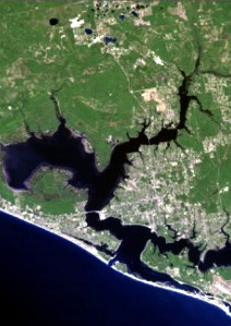
to meet your deadlines. Having surveyed Bay County Florida and the surrounding
areas for over 20 years we know the lay of the land and have an
immense data pool to ensure our accuracy. We are licensed with the
State of Florida and unlike many we are insured as well. Sea Level
is a member of The Florida Surveying and Mapping Society.
Sea Level Surveying and Mapping, Inc. is a
company rich in experience and expertise. We pride ourselves in
providing quality surveying, affordable pricing and prompt response
to meet your deadlines. Having surveyed Bay County Florida and the surrounding
areas for over 20 years we know the lay of the land and have an
immense data pool to ensure our accuracy. We are licensed with the
State of Florida and unlike many we are insured as well. Sea Level
is a member of The Florida Surveying and Mapping Society.
Services: Mortgage Surveys - Subdivisions - As-Built Surveys for Commercial & Residential - Land and Water Surveys - FEMA Elevation Certificates for Flood Insurance - Mean High Water Line Surveys - Legal Descriptions - ALTA/ACSM Surveys - Easement and Right of Way Surveys - Coastal Construction Control Line Surveys - Wetland Jurisdiction Line Location - Construction Layout - Topographic Surveys - Riparian Rights Surveys - Dock & Sea Wall Permits - Volumetrics - more...
Quick Links: |
 The Florida Surveying and Mapping Society |
 Bay County Property Appraiser |
Bay County Clerk of Courts |